
Binder 18: Photographs and Images
Files
Download
Download Full Text (4.4 MB)
Preview
Creation Date
1995
Time Period
circa 1990s
Abstract
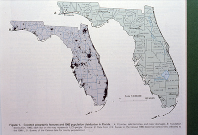
A image of two maps, one displaying the different Florida counties and the other displaying population distribution.
Alt Text
A map of Florida showing counties and population distribution from the 1980s. The state's outline is highlighted with various shades indicating different population densities.
Keywords
Maps, Counties, Population density
Extent
1 color photograph
Physical Collection
Box
6
Folder
Binder 18
Digital Date
2024
Media Type
Color photographs
Identifier
O19-02781
Recommended Citation
Ogden, John C., "Map of Florida Counties and Population Distribution" (1995). Binder 18: Photographs and Images. Image 355.
https://digitalcommons.usf.edu/ogden18_images/355
Keywords
Maps, Counties, Population density
Rights Statement

