
Binder 18: Photographs and Images
Files
Download
Download Full Text (6.3 MB)
Preview
Creation Date
5-21-1989
Abstract
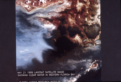
A map of the discolored water in Florida Bay in the Florida Everglades.
Alt Text
Satellite view of a coastal area with labeled locations and water patterns, taken on May 21, 1989. The image shows distinct landmasses and varying water colors.
Keywords
Bodies of water, Bays, Corals, Water quality, Environmental mapping
Extent
1 color photograph
Physical Collection
Box
6
Folder
Binder 18
Digital Date
2024
Media Type
Color photographs
Identifier
O19-02657
Recommended Citation
Ogden, John C., "Mapping of Discolored Water in Florida Bay in Florida Everglades, B" (1989). Binder 18: Photographs and Images. Image 234.
https://digitalcommons.usf.edu/ogden18_images/234
Keywords
Bodies of water, Bays, Corals, Water quality, Environmental mapping
Image Location
Latitude
25.000280
Longitude
-80.749730
Rights Statement

