
Binder 18: Photographs and Images
Files
Download
Download Full Text (5.4 MB)
Preview
Creation Date
1980
Abstract
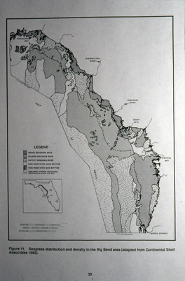
A photograph of a map in seagrass species and distribution along the Big Bend of Florida.
Alt Text
A map showing the distribution and density of seagrass in the Big Bend area of the State of Florida, with various regions shaded differently according to a legend. The inset provides a location reference within a larger geographical context.
Keywords
Maps, Geology
Extent
1 color photograph
Physical Collection
Box
6
Folder
Binder 18
Digital Date
2024
Media Type
Color photographs
Identifier
O19-02558
Recommended Citation
Ogden, John C., "Maps of Seagrass Species and Distribution in Big Bend Florida" (1980). Binder 18: Photographs and Images. Image 124.
https://digitalcommons.usf.edu/ogden18_images/124
Keywords
Maps, Geology
Rights Statement

