
Files
Download Full Text (1.7 MB)
Preview
Creation Date
3-3-1959
Abstract
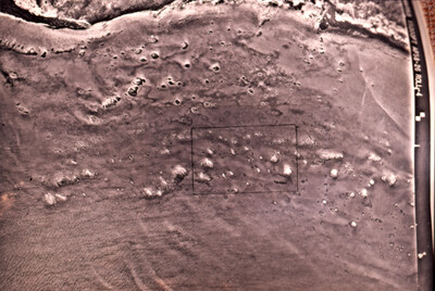
A layered map of the 31 patch reefs at Anegada, British Virgin Islands. March 3, 1959.
Alt Text
Red map of a reef patch appearing textured with reef spots and barren in majority areas . A rectangular outline marks a specific area within the terrain on center, slightly right side.
Keywords
Coral reefs and islands, Reef ecology, Marine sciences, Travel, Maps, United States. Army Air Forces
Extent
1 map
Physical Collection
Box
4
Folder
Binder 10
Digital Date
2024
Media Type
Maps
Identifier
O19-01283
Recommended Citation
Ogden, John C., "Map, U.S. Air Force Map of Anegada Patch Reefs at 1,500 feet, British Virgin Islands, March 3, 1959" (1959). Binder 10: Photographs and Images. Image 36.
https://digitalcommons.usf.edu/ogden10_images/36
Keywords
Coral reefs and islands, Reef ecology, Marine sciences, Travel, Maps, United States. Army Air Forces
Image Location
Latitude
18.724209
Longitude
-64.381821
Rights Statement

