
Files
Download Full Text (1.4 MB)
Preview
Creation Date
10-15-1998
Abstract
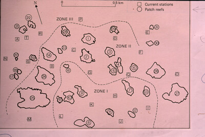
A map of the 31 patch reefs and their three zones recorded on October 15-20, 1998 at Anegada, British Virgin Islands.
Alt Text
A pink map with labeled zones and marked locations of current stations and patch reefs, divided into three distinct areas: Zone I, Zone II, and Zone III. The map includes a scale indicator and a compass direction arrow for orientation.
Keywords
Coral reefs and islands, Reef ecology, Marine sciences, Travel, Maps
Extent
1 map
Physical Collection
Box
4
Folder
Binder 10
Language
English
Digital Date
2024
Media Type
Maps
Identifier
O19-01282
Recommended Citation
Ogden, John C., "Map, Anegada Patch Reefs and Zones, British Virgin Islands, October 15, 1998" (1998). Binder 10: Photographs and Images. Image 35.
https://digitalcommons.usf.edu/ogden10_images/35
Keywords
Coral reefs and islands, Reef ecology, Marine sciences, Travel, Maps
Image Location
Latitude
18.724209
Longitude
-64.381821
Rights Statement

