
Le Moyne Plates
Alternative Title
Delineation of Fort Caroline
Files
Download Full Text (2.4 MB)
Preview
Creation Date
January 1591
Abstract
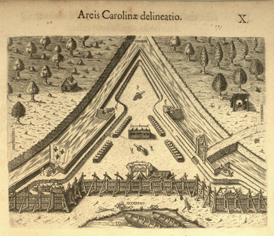
Plate 10 from the Brevis narratio. A plate showing the triangular shape of Fort Caroline near Jacksonville, Florida.
Alt Text
An illustration of a triangular fortification with various structures and people inside. The surrounding area includes trees and fields, with the fort's layout clearly depicted.
Keywords
Florida Huguenot colony (1562-1565), Timucua, Fort Caroline National Memorial (Jacksonville Fla.), Fortification
Extent
1 plate
Subject: geographic
Duval County (Fla.)
Physical Collection
Vault
Call Number
Language
Latin
Media Type
Plates (Illustrations)
Identifier
L11-00010
Recommended Citation
Le Moyne de Morgues, Jacques and Bry, Theodor de, "Plate 10, Arcis Carolinae delineatio" (1591). Le Moyne Plates. Image 10.
https://digitalcommons.usf.edu/le_moyne/10
Keywords
Florida Huguenot colony (1562-1565), Timucua, Fort Caroline National Memorial (Jacksonville Fla.), Fortification
Rights Statement

