
Karst in 3D
Saxon Lake Sinkhole 3D Laser Scanning Model
Files
View 3D Model
Publication Date
2017
Abstract
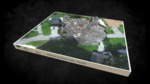
On July 25, 2017, University of South Florida Library’s Digital Heritage and Humanities Collections (DHHC) researchers conducted a 3D survey of the Pasco County sinkhole near Saxon Lake. We are also working to integrate data with collaboration from the USF School of Geosciences, who were collecting Ground Penetrating Radar survey data in conjunction with our GPS work. Additionally, Halo Imaging have been providing access to their RTK drone imagery that has been collected on multiple days and is allowing for meaningful comparison data. The DHHC and USF Libraries are creating a database archive of this research effort, and a web application portal that shares historic maps and information about the environmental history of this area (see: http://arcg.is/0LuCnL ).
To learn more: http://wusfnews.wusf.usf.edu/post/studying-pasco-sinkhole-has-personal-professional-meaning-usf-researcher#stream/0
Keywords
drone, geomagic, laserscanning, florida, gps, structure from motion, karst, disaster, meta geo, sinkhole, faro x330, pasco county, land o lakes, geo djj27wmc0qgu, photogrammetry
Alt Text
A 3D model of a sinkhole in a residential neighborhood.
Recommended Citation
University of South Florida Libraries, "Saxon Lake Sinkhole 3D Laser Scanning Model" (2017). Karst in 3D. 6.
https://digitalcommons.usf.edu/karst_in_3d/6
