
Gandy Photographs - Streets, Buildings, and Construction
Files
Download
Download Full Text (40.5 MB)
Preview
Creation Date
1970
Time Period
circa 1970s-1980s
Abstract
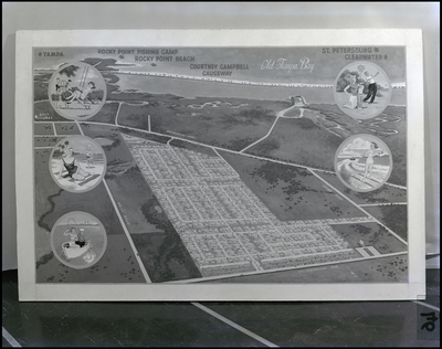
A map of Old Tampa Bay, including suburb of Town N' Country, Florida.
Alt Text
A map illustrating the Courtney Campbell Causeway area with labeled locations and scenic illustrations. The map includes Tampa Bay, Rocky Point Beach, and nearby cities like Tampa, St. Petersburg, and Clearwater.
Keywords
Neighborhoods, Houses, Urban development
Extent
1 black-and-white photograph
Physical Collection
Box
2
Digital Date
2024
Media Type
Black-and-white photographs
Feedback
Click to provide feedback about the metadata for this photograph.
Identifier
Gandy 02_1487_Undetermined
Recommended Citation
Gandy, George Skip IV, "Map, Old Tampa Bay" (1970). Gandy Photographs - Streets, Buildings, and Construction. Image 335.
https://digitalcommons.usf.edu/gandy_street/335
Keywords
Neighborhoods, Houses, Urban development
Rights Statement