
Gandy Photographs - Streets, Buildings, and Construction
Files
Download Full Text (3.8 MB)
Preview
Creation Date
1997
Time Period
circa 1997
Abstract
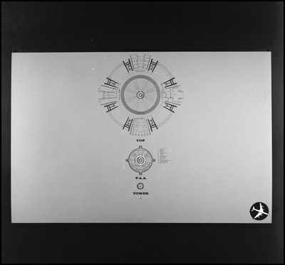
A detailed floor plan of the Federal Aviation Administration (FAA) control tower and top level for the proposed Jacksonville Airport. The circular layout includes operational rooms, support areas, and the central air traffic control space designed for managing airport operations.
Alt Text
A circular diagram with multiple sections and labels, likely representing a floor plan of a building. The bottom part includes smaller diagrams labeled "TOP," "FAA," and "TOWER."
Keywords
Airports, Architectural drawings, United States. Federal Aviation Administration, Airport control towers, Jacksonville International Airport
Extent
1 black-and-white photograph
Subject: geographic
Duval County (Fla.); Jacksonville (Fla.)
Physical Collection
Box
7
Digital Date
2024
Media Type
Black-and-white photographs
Feedback
Click to provide feedback about the metadata for this photograph.
Identifier
Gandy 07_1327_Undetermined
Recommended Citation
Gandy, George Skip IV, "Federal Aviation Administration Tower and Top Level Plan, Proposed Jacksonville Airport, Jacksonville, B" (1997). Gandy Photographs - Streets, Buildings, and Construction. Image 1281.
https://digitalcommons.usf.edu/gandy_street/1281
Keywords
Airports, Architectural drawings, United States. Federal Aviation Administration, Airport control towers, Jacksonville International Airport
Image Location
Latitude
30.4915234
Longitude
-81.6849191
Rights Statement