
Gandy Photographs - Streets, Buildings, and Construction
Files
Download Full Text (4.5 MB)
Preview
Creation Date
1970
Time Period
circa 1970
Abstract
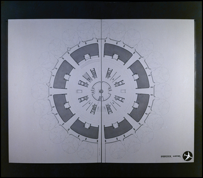
A design plan for the service level of the proposed Jacksonville Airport, showcasing a semicircular layout with multiple gate areas for aircraft. The drawing details the arrangement of terminal spaces and service areas adjacent to airplane docking zones.
Alt Text
A detailed architectural floor plan of a circular building, showing various rooms and corridors. The layout includes multiple sections with labeled areas and pathways.
Keywords
Airports, Architectural drawings, Airport buildings, Floor plans, Jacksonville International Airport
Extent
1 black-and-white photograph
Subject: geographic
Duval County (Fla.); Jacksonville (Fla.)
Physical Collection
Box
7
Digital Date
2024
Media Type
Black-and-white photographs
Feedback
Click to provide feedback about the metadata for this photograph.
Identifier
Gandy 07_1300_Undetermined
Recommended Citation
Gandy, George Skip IV, "Service Level Plan, Proposed Jacksonville Airport, Jacksonville, B" (1970). Gandy Photographs - Streets, Buildings, and Construction. Image 1271.
https://digitalcommons.usf.edu/gandy_street/1271
Keywords
Airports, Architectural drawings, Airport buildings, Floor plans, Jacksonville International Airport
Image Location
Latitude
30.4915234
Longitude
-81.6849191
Rights Statement