

Gandy Photographs - Natural Scenes and the Environment
Files
Download Full Text (4.0 MB)
Preview
Creation Date
1972
Time Period
circa 1972-1973
Abstract
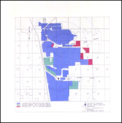
A map of the Payne Creek-Palmetto Phosphate Mine area near Fort Green, Florida. Included is the location of two washers and railroad lines.
Alt Text
A map with various colored sections and a legend indicating different areas and features, including mined-out or settling areas, palmetto washer locations, and bulldozer trails. The map is overlaid on a grid system with numbered sections.
Keywords
Polk Phosphate Mining District, Phosphate mines and mining, Agrico Chemical Company
Extent
1 map
Subject: geographic
Hardee County (Fla.); Fort Green (Fla.); Payne Creek (Fla.)
Physical Collection
Box
1
Language
English
Digital Date
2024
Media Type
Maps
Feedback
Click to provide feedback about the metadata for this photograph.
Identifier
Gandy 01_0235
Creative Commons

This work is licensed under a Creative Commons Attribution 3.0 License.
Recommended Citation
Gandy, George Skip IV, "Map of Payne Creek-Palmetto Phosphate Mine Area, Fort Green, Florida, A" (1972). Gandy Photographs - Natural Scenes and the Environment. Image 15.
https://digitalcommons.usf.edu/gandy_environmental/15
Keywords
Polk Phosphate Mining District, Phosphate mines and mining, Agrico Chemical Company
