

Files
Download
Download Full Text (17.0 MB)
Preview
Creation Date
2-9-1989
Abstract
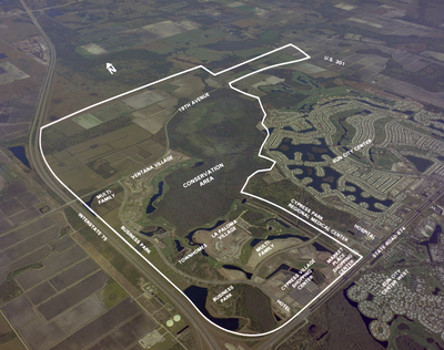
A map of Sun City Center and I-75, highlighting conservation areas, distinct villages, shopping centers, and various other notable landmarks.
Alt Text
Aerial view of a large, outlined area with various labeled sections and roads. The landscape includes fields, water bodies, and developed neighborhoods.
Keywords
Interstate 75, Aerial photography, Roads, Lakes, Maps
Extent
1 color photograph
Subject: geographic
Hillsborough County (Fla.); Sun City Center(Fla.)
Physical Collection
Box
27
Digital Date
2024
Media Type
Color photographs
Feedback
Identifier
Gandy 27_1767
Recommended Citation
Gandy, George Skip IV, "Sun City and I-75 Map, Sun City Center, A" (1989). Gandy Photographs - Aerials. Image 796.
https://digitalcommons.usf.edu/gandy_aerials/796
Keywords
Interstate 75, Aerial photography, Roads, Lakes, Maps
