

Files
Download Full Text (5.8 MB)
Preview
Creation Date
1920
Time Period
circa 1920s
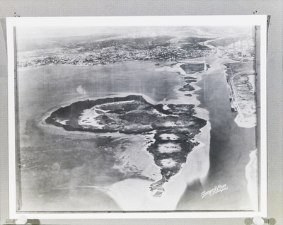
Abstract
An aerial view of Davis Islands in Tampa, Florida, before significant development. The city of Tampa and the surrounding bay are visible in the background.
Alt Text
Aerial view of a coastal area with a prominent island and surrounding waterways, framed by a cityscape in the background. The photograph captures intricate details of land formations and urban structures from above.
Keywords
Aerial views, Urban development, Islands
Extent
1 black-and-white photograph
Subject: geographic
Hillsborough County (Fla.); Tampa (Fla); Davis Islands (Tampa, Fla.)
Physical Collection
Box
12
Digital Date
2024
Media Type
Black-and-white photographs
Feedback
Click to provide feedback about the metadata for this photograph.
Identifier
Gandy 12_0963_Undetermined
Recommended Citation
Gandy, George Skip IV, "Aerial View of Predevelopment Davis Islands" (1920). Gandy Photographs - Aerials. Image 314.
https://digitalcommons.usf.edu/gandy_aerials/314
Keywords
Aerial views, Urban development, Islands
