

Files
Download Full Text (6.6 MB)
Preview
Creation Date
1920
Time Period
circa 1920s
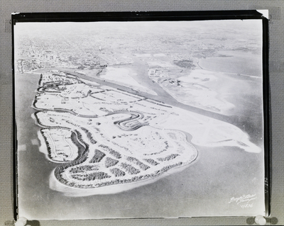
Abstract
An aerial view of Davis Islands in Tampa, Florida. The image shows the early development of the islands, with roads and plots laid out in a grid pattern surrounded by water. The city of Tampa is visible in the distance.
Alt Text
A black-and-white aerial view of a coastal area with winding roads and buildings. The landscape includes water bodies and appears to be densely developed.
Keywords
Aerial views, Urban development, Islands
Extent
1 black-and-white photograph
Subject: geographic
Hillsborough County (Fla.); Tampa (Fla); Davis Islands (Tampa, Fla.)
Physical Collection
Box
12
Digital Date
2024
Media Type
Black-and-white photographs
Feedback
Click to provide feedback about the metadata for this photograph.
Identifier
Gandy 12_0962_Undetermined
Recommended Citation
Gandy, George Skip IV, "Aerial View of Early Davis Islands" (1920). Gandy Photographs - Aerials. Image 313.
https://digitalcommons.usf.edu/gandy_aerials/313
Keywords
Aerial views, Urban development, Islands
