

Gandy Photographs - General, Culture, Politics
Files
Download Full Text (22.3 MB)
Preview
Creation Date
1970
Time Period
circa 1970s
Abstract
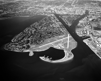
Aerial view of Davis Islands and Harbour Island.
Alt Text
Aerial view of a coastal area with an airport runway and surrounding urban development, separated by waterways. The landscape includes residential areas and infrastructure.
Keywords
Aerial views, Yacht clubs, Airports
Extent
1 black-and-white aerial photograph
Subject: geographic
Hillsborough County (Fla.); Tampa (Fla.); Davis Islands (Tampa, Fla.); Hillsborough Bay (Fla.)
Physical Collection
Digital Date
2018
Media Type
Aerial photographs
Feedback
Click to provide feedback about the metadata for this photograph.
Identifier
G34-00242-003
Creative Commons

This work is licensed under a Creative Commons Attribution 3.0 License.
Recommended Citation
Gandy, George Skip IV, "Aerial View of Bayshore Boulevard and Davis Islands" (1970). Gandy Photographs - General, Culture, Politics. Image 167.
https://digitalcommons.usf.edu/gandy/167
Keywords
Aerial views, Yacht clubs, Airports
