

Florida Ornithological Society - Images
Files
Download
Download Full Text (29.3 MB)
Preview
Creation Date
1-1-1973
Time Period
circa 1973
Abstract
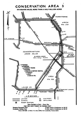
A map of Lake Okeechobee Conservation Areas 3A and 3B in southern Florida.
Alt Text
A map entitled "Conservation Area 3." There is a legend at the bottom showing levees, canals, pump stations, culverts, and spillways.
Keywords
Land conservation
Extent
1 map
Subject: geographic
Lake Okeechobee (Fla.)
Physical Collection
Box
43
Folder
1
Media Type
Maps
Identifier
fos_images_3744
Recommended Citation
Unknown, "Map of Lake Okeechobee Conservation Area 3" (1973). Florida Ornithological Society - Images. Image 2745.
https://digitalcommons.usf.edu/fos_images/2745
Keywords
Land conservation
Image Location
Latitude
26.905686
Longitude
-80.964022
Rights Statement

