Florida Photograph Collection
Files
Download Full Text (65.9 MB)
Preview
Creation Date
1937
Time Period
circa 1937-1938
Abstract
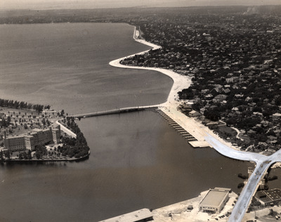
An aerial view of Bayshore Boulevard and the bridge connecting Davis Islands and Tampa Bay.
Alt Text
Aerial view of a coastal city with a grid-like street layout, showing buildings and infrastructure along the shoreline.
Keywords
Streets, Aerial views
Extent
1 black-and-white photograph
Subject: geographic
Hillsborough County (Fla.); Tampa (Fla.)
Physical Collection
Box
23
Folder
2
Media Type
Black-and-white photographs
Note
Bayshore Boulevard's wide path and seawalls were mainly built by the Florida Works Progress Administration between 1935 and 1938. The sidewalk on the Tampa Bay side is said to be the longest continuous sidewalk in the world at 6.5 miles.
Identifier
florida_photograph_1111
Recommended Citation
Thoner, Carl L., "Aerial View of Bayshore Boulevard, Tampa" (1937). Florida Photograph Collection. Image 112.
https://digitalcommons.usf.edu/florida_photograph/112
Keywords
Streets, Aerial views
Image Location
Latitude
27.938382
Longitude
-82.46244
Rights Statement