

Florida Maps Collection
Files
Download
Download Full Text (686 KB)
Preview
Publisher
Robert Sayer
Creation Date
1788
Abstract
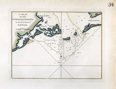
A map of the plan of entrances of Tampa Bay while it was a part of East Florida. It shows water depths in fathoms, islands, keys, and inland waters.
Alt Text
Chart showing the entrance to Tampa Bay with depths labeled. Shown are Mullett Keys, Castor Key, Pollux Key, and Long Island Key.
Keywords
Nautical charts, Navigation
Scale
126710, Scale [ca. 1:126,710].
Extent
1 map
Subject: geographic
Tampa Bay (Fla.)
Physical Collection
Rare Map Collection
Language
English
Media Type
Map
Identifier
U15-9032
Recommended Citation
Sayer, Robert, "Map, Plan of the Entrances of Tampa Bay, on the West Coast of East Florida, 1788, Color" (1788). Florida Maps Collection. Image 86.
https://digitalcommons.usf.edu/fl_maps_collection/86
Keywords
Nautical charts, Navigation
Rights Statement

