

Florida Maps Collection
Files
Download Full Text (834 KB)
Preview
Publisher
Anthony Finley
Creation Date
1826
Abstract
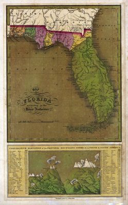
A map of Florida showing the counties, cities and towns, inland waters, and railroads. Included below the map is a table and illustration of the "Comparative elevation of the principal mountains cities & c. in North and South America."
Alt Text
Map of Florida with counties shown in varying colors. Only 7 counties are shown, Escambia, Walton, Jackson, Gadsen, Leon, Duval and St. Johns. Below the map is a graphic mountain elevations of North and South America.
Keywords
Mountains
Scale
3168000, Scale [ca. 1:3,168,000].
Extent
1 map
Physical Collection
Rare Map Collection
Call Number
Language
English
Media Type
Map
Identifier
U15-0038
Recommended Citation
Young, James Hamilton, "Map, Florida According to the Latest Authorities, 1826" (1826). Florida Maps Collection. Image 52.
https://digitalcommons.usf.edu/fl_maps_collection/52
Keywords
Mountains
Rights Statement

