

Florida Maps Collection
Files
Download
Download Full Text (925 KB)
Preview
Publisher
R. Baldwin
Creation Date
1765
Abstract
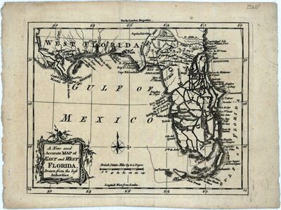
A map of east and west Florida. West Florida in this map extends to the Mississippi River including New Orleans. This map also shows exaggerated intercoastal waterways, cities, and towns.
Alt Text
Map of Florida with the peninsula depicted as a series of islands.
Scale
5200000, Scale [ca. 1:5,200,000]
Extent
1 map
Subject: geographic
Gulf Coast (U.S.)
Language
English
Media Type
Map
Identifier
U15-0021
Recommended Citation
Prockter, J., "Map, New and Accurate Map of East and West Florida, 1765, Black and White" (1765). Florida Maps Collection. Image 48.
https://digitalcommons.usf.edu/fl_maps_collection/48
Rights Statement

