

Florida Maps Collection
Files
Download Full Text (745 KB)
Preview
Publisher
United States. Army. Corps of Engineers
Creation Date
1882
Abstract
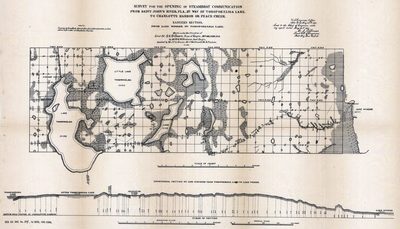
This is a hand colored map of the opening of steamboat communication from the St. Johns River to Charlotte Harbor eastern section by way of Tohopekaliga Lake circa 1881. There is also a "Longitudinal Section On Line Surveyed from Tohopekaliga Lake to Lake Winder" below.
Alt Text
A map made to survey for the opening of steamboat communication from the St. Johns River "by way of Tohopekaliga Lake" to Charlotte Harbor or Peace Creek.
Keywords
Canals, Steamboats
Scale
134640, Scale [ca. 1:134,640].
Extent
1 elevation map
Subject: geographic
Osceola County (Fla.); Brevard County (Fla.); Tohopekaliga Lake (Fla.); Lake Winder (Fla.)
Physical Collection
Rare Map Collection
Language
English
Media Type
Elevations (Orthographic projections)
Identifier
U15-0094
Recommended Citation
Williamson, W. G. and Gillmore, Quincy Adams, "Elevation Map, Survey for the Opening of Steamboat Communication, Eastern Section from Lake Winder to Tohopekaliga Lake, 1882" (1882). Florida Maps Collection. Image 46.
https://digitalcommons.usf.edu/fl_maps_collection/46
Keywords
Canals, Steamboats
Rights Statement

