

Florida Maps Collection
Files
Download
Download Full Text (1.2 MB)
Preview
Publisher
U.S. Coast & Geodetic Survey
Creation Date
1887
Abstract
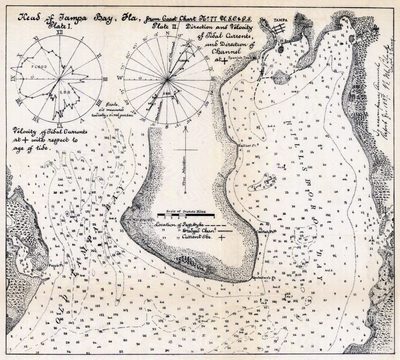
A map and nautical chart of the Tampa Bay in Florida. Includes water depths.
Alt Text
Nautical Chart showing depths for the Hillsborough bay and Old Tampa Bay.
Keywords
Nautical charts, Navigation
Scale
Scale not determined.
Extent
1 map
Subject: geographic
Hillsborough Bay (Fla.), Tampa Bay (Fla.)
Physical Collection
Touchton Map Collection
Holding Location
Tampa Bay History Center
Language
English
Media Type
Map
Identifier
U15-9030
Recommended Citation
Black, N. M., "Map, Head of Tampa Bay, Florida, 1887" (1887). Florida Maps Collection. Image 38.
https://digitalcommons.usf.edu/fl_maps_collection/38
Keywords
Nautical charts, Navigation
Rights Statement

