

Florida Maps Collection
Files
Download Full Text (1.2 MB)
Preview
Publisher
Florida Land & Immigration Co.
Creation Date
1876
Abstract
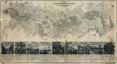
A map showing ranges, townships, and sections in lands owned by Florida Land and Immigration Company and Florida Railroad bondholders. Area covered includes part of Marion, Levy, Alachua, Bradford, Baker, Duval, and Nassau Counties.
Alt Text
Map of the 650,000 acres of land owned by the Florida Land and Immigration company. The bottom of the page shows images and information on several attractions.
Keywords
Real property
Scale
253440, Scale [ca. 1:253,440].
Extent
1 map
Subject: geographic
Marion County (Fla.); Levy County (Fla.); Alachua County (Fla.); Bradford County (Fla.); Baker County (Fla.); Duval County (Fla.); Nassau County (Fla.)
Physical Collection
Rare Map Collection
Language
English
Media Type
Map
Identifier
U15-0067
Recommended Citation
Koerner, E. O.W., "Map, 650,000 Acres of Land Owned and Controlled by the Florida Land and Immigration Company, 1876" (1876). Florida Maps Collection. Image 35.
https://digitalcommons.usf.edu/fl_maps_collection/35
Keywords
Real property
Rights Statement

