

Florida Maps Collection
Files
Download
Download Full Text (1.4 MB)
Preview
Publisher
Adam & Charles Black
Creation Date
1845
Time Period
circa 1845
Abstract
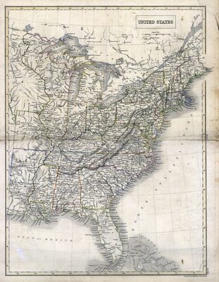
A map of the United States as it existed in 1845 between when Florida was admitted as a state in March 1845 and when Texas was admitted in December 1845. Included the name of cities and towns, and bodies of water. Lake Okeechobee is labelled as Lake Macaco.
Alt Text
Map of the Eastern United States with states and cities labeled.
Scale
6200000, Scale [1:6,200,000].
Extent
1 map
Physical Collection
Rare Map Collection
Call Number
Language
English
Media Type
Map
Identifier
U15-0036
Recommended Citation
Hall, Sidney, "Map, United States, circa 1845" (1845). Florida Maps Collection. Image 34.
https://digitalcommons.usf.edu/fl_maps_collection/34
Rights Statement

