

Florida Maps Collection
Alternative Title
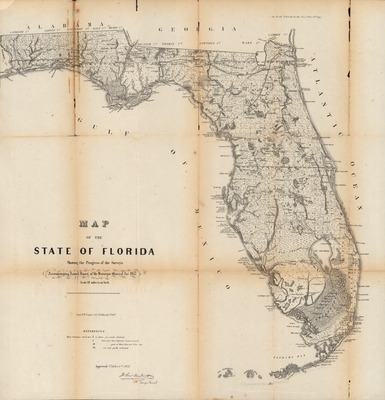
Accompanying Annual report of the Surveyor General for 1857
Files
Download Full Text (659.1 MB)
Preview
Publisher
Wagner & McGuigan's Lithography
Creation Date
10-1-1857
Abstract
A map of the state of Florida showing the progress of land surveying at the time. Includes forts, railroads, and major water features.
Alt Text
A map of the state of Florida showing township and range, railroads, forts, and major water features.
Keywords
Maps, Forts and fortifications, Surveying, Railroads, Cities and towns
Scale
1140480, Scale [1:1,140,480].
Extent
1 map of H 65.7 cm by W 62.5 cm
Physical Collection
General Map Collection
Language
English
Digital Date
2026
Media Type
Map
Recommended Citation
Wagner & McGuigan's Lithography, "Map of the State of Florida, Showing Progress of the Surveys, 1857" (1857). Florida Maps Collection. Image 178.
https://digitalcommons.usf.edu/fl_maps_collection/178
Keywords
Maps, Forts and fortifications, Surveying, Railroads, Cities and towns
Rights Statement

