

Florida Maps Collection
Alternative Title
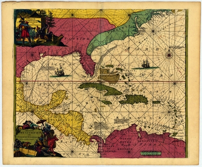
Map, Coastal Tracts of the West Indies and the Caribbean Islands, 1715
Files
Download
Download Full Text (55.0 MB)
Preview
Publisher
Frederik de Wit
Creation Date
1715
Abstract
A map of the Caribbean from 1715.
Alt Text
Illustrative map of the Caribbean showing the Southeast United States, Mexico, Cuba Central America, and Northern South America.
Scale
8500000, Scale [ca. 1:8,500,00].
Extent
1 map
Subject: geographic
Caribbean Area
Physical Collection
Touchton Map Collection
Holding Location
Tampa Bay History Center
Language
Latin
Media Type
Map
Identifier
U15-9014
Recommended Citation
de Wit, Frederik, "Map, Indiarum Occidentalium Tractus Littorales cum Insulis Caribicis, 1715" (1715). Florida Maps Collection. Image 171.
https://digitalcommons.usf.edu/fl_maps_collection/171
Rights Statement

