

Florida Maps Collection
Files
Download
Download Full Text (1.3 MB)
Preview
Publisher
J.H. Colton & Company
Creation Date
1855
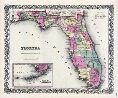
Abstract
A map of Florida showing the counties, cities and towns, inland waters, railroads and roads. There is an inset map of the Florida Keys. Section township range (STR) is shown.
Alt Text
Map of Florida with counties shown in varying colors. An inset map shows the southern tip of Florida.
Scale
2520000, Scale [ca. 1:2,520,000]
Extent
1 map
Physical Collection
Rare Map Collection
Call Number
Language
English
Media Type
Map
Identifier
U15-0084
Recommended Citation
J.H. Colton & Company, "Map, Florida, 1855" (1855). Florida Maps Collection. Image 17.
https://digitalcommons.usf.edu/fl_maps_collection/17
Rights Statement

