

Florida Maps Collection
Files
Download
Download Full Text (11.8 MB)
Preview
Publisher
Jacob Weiss
Creation Date
1860
Abstract
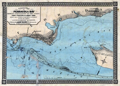
A map of the Pensacola area showing all the fortifications including Fort Pickens and topography of the coast from the latest government survey. Depths shown by form lines.
Alt Text
A map of the Pensacola area showing all the fortifications including Fort Pickens and topography of the coast.
Keywords
U.S. Civil War (1861-1865), Fortification
Scale
60830, Scale [ca. 1:60,830].
Extent
1 map
Subject: geographic
Escambia County (Fla.); Pensacola (Fla.); Santa Rosa Island (Fla.); Pensacola Bay (Fla.)
Physical Collection
Rare Map Collection
Language
English
Media Type
Map
Identifier
U15-0116
Recommended Citation
Weiss, Jacob, "Map, Correct Map of Pensacola Bay, 1860" (1860). Florida Maps Collection. Image 164.
https://digitalcommons.usf.edu/fl_maps_collection/164
Keywords
U.S. Civil War (1861-1865), Fortification
Rights Statement

