

Florida Maps Collection
Alternative Title
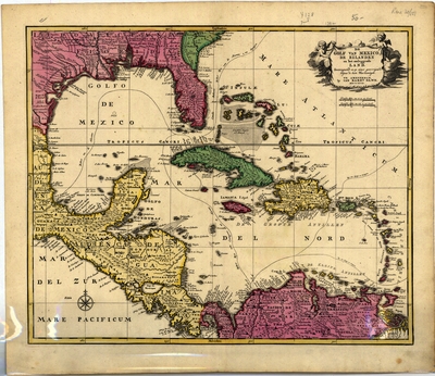
Map, Gulf of Mexico, the Islands and Surrounding Land, 1792
Files
Download
Download Full Text (54.1 MB)
Preview
Creation Date
1792
Abstract
A map in dutch of the Gulf of Mexico showing the Southeast United States, Mexico, Cuba, the Bahamas, and Northern South America. Several nautical travel routes are shown.
Alt Text
A map in Dutch of the Gulf of Mexico showing the Southeast United States, Mexico, Cuba, the Bahamas, and Northern South America. Several nautical travel routes are shown.
Scale
13800000, Scale [ca. 1:13,800,000]
Extent
1 map
Subject: geographic
Caribbean Area, Gulf Coast (U.S.)
Language
Dutch
Media Type
Map
Identifier
U15-0030
Recommended Citation
Elwe, Jan Barend, "Map, Golf van Mexico de Eilanden en Het Omleggende Land, 1792" (1792). Florida Maps Collection. Image 163.
https://digitalcommons.usf.edu/fl_maps_collection/163
Rights Statement

