

Florida Maps Collection
Alternative Title
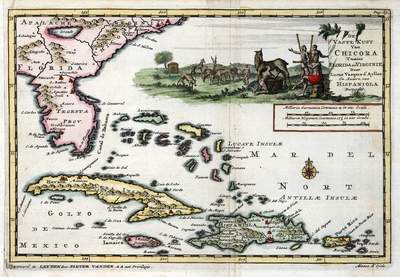
Map, Mainland Coast of Chicora between Florida and Virginia, 1706
Files
Download Full Text (14.5 MB)
Preview
Publisher
Pieter Vander Aa
Creation Date
1706
Abstract
A map of Florida and parts of the Caribbean including the Bahamas, Cuba, Jamaica, Haiti, Dominican Republic, Puerto Rico and the U.S. Virgin Islands.
Alt Text
A map of Florida and parts of the Caribbean including the Bahamas, Cuba, Jamaica, Haiti, Dominican Republic, Puerto Rico and the U.S. Virgin Islands.
Scale
13300000, Scale [ca.1:13,300,000].
Extent
1 map
Subject: geographic
Bahamas; Cuba; Jamaica; Haiti; Dominican Republic; Puerto Rico; U.S. Virgin Islands
Language
Dutch; French
Media Type
Map
Identifier
U15-9059
Recommended Citation
Vazquez de Ayllon, Lucas and de Ojeda, Alonso, "Map, De Vaste Kust van Chicora Tussen Florida en Virginie, 1706" (1706). Florida Maps Collection. Image 154.
https://digitalcommons.usf.edu/fl_maps_collection/154
Rights Statement

