

Florida Maps Collection
Files
Download
Download Full Text (147.4 MB)
Preview
Publisher
Leve & Alden Printing Company
Creation Date
1856
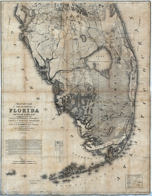
Abstract
A map of the peninsula of Florida from Tampa south. Shows forts, wagon roads, Indigenous boundaries, battle grounds, types of trees, light houses and other towns and cities.
Alt Text
A map of the peninsula of Florida from Tampa south showing forts, wagon roads, Indigenous boundaries, battle grounds, types of trees, light houses and other towns and cities.
Keywords
Forts and fortifications Roads, Trails
Scale
400000, Scale 1:400,000
Extent
1 map
Subject: geographic
Tampa Bay (Fla.)
Physical Collection
Rare Map Collection
Language
English
Media Type
Map
Identifier
U15-0113
Recommended Citation
Ives, J. C., "Map, Military Map of the Peninsula of Florida South of Tampa Bay, 1856" (1856). Florida Maps Collection. Image 152.
https://digitalcommons.usf.edu/fl_maps_collection/152
Keywords
Forts and fortifications Roads, Trails
Rights Statement

