

Florida Maps Collection
Files
Download Full Text (783 KB)
Preview
Publisher
Belmore Florida Land Company
Creation Date
1885
Abstract
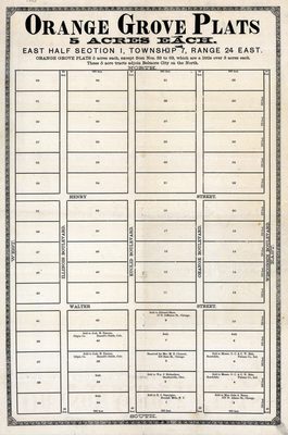
A map of orange grove plats in Belmore, Florida. It shows streets and owners names. Orange grove plats are 5 acres each, except numbers 33 to 63 which are a little over 3 acres each. These tracts ajoin Belmore City on the north.
Alt Text
Plat map of Orange Grove Plats, located near Belmore City, Florida. Parcels on the plat contain information on sold and reserved properties.
Keywords
Real property, Orange groves
Scale
Scale not given
Extent
1 map
Subject: geographic
Clay County (Fla.); Belmore (Fla.)
Physical Collection
Rare Map Collection
Language
English
Media Type
Map
Identifier
U15-0075
Recommended Citation
Belmore Florida Land Company, "Map, Orange Grove Plats, 5 Acres Each, East Half Section 1, Township 7, Range 24 East, 1885" (1885). Florida Maps Collection. Image 14.
https://digitalcommons.usf.edu/fl_maps_collection/14
Keywords
Real property, Orange groves
Rights Statement

