

Florida Maps Collection
Files
Download
Download Full Text (9.9 MB)
Preview
Publisher
Matthews-Northrup Company
Creation Date
1892
Abstract
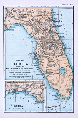
A map of Florida showing cities and towns, railroads, inland waters, some physical features and prime meridians from Washington and Greenwich. There is an inset map of the "Western Part of Florida."
Alt Text
A map of Florida showing cities and towns, railroads, inland waters, and some physical features. An inset map is shown for the Florida panhandle.
Scale
4752000, Scale [ca.1:4,752,000].
Extent
1 map
Language
English
Media Type
Map
Identifier
U15-9060
Recommended Citation
Sweetser, M. F., "Map, Florida Engraved for King's Handbook of the United States, 1892" (1892). Florida Maps Collection. Image 137.
https://digitalcommons.usf.edu/fl_maps_collection/137
Rights Statement

