

Florida Maps Collection
Files
Download
Download Full Text (6.5 MB)
Preview
Publisher
Wagner & Debes
Creation Date
1909
Abstract
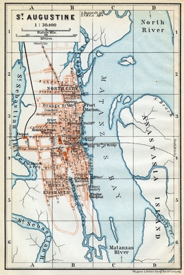
A map of St. Augustine showing city roads, railroads, bridges, locations of places (hospital, municipal building, etc.), Castillo de San Marcos (which was known at this time as Fort Marion), and inland waters.
Alt Text
Map showing the plan of St. Augustine with streets, buildings, and waterbodies marked.
Scale
30400, Scale 1:30,400.
Extent
1 map
Subject: geographic
St. Johns County (Fla.); St. Augustine (Fla.)
Language
English
Media Type
Map
Identifier
U15-9058
Recommended Citation
Wagner & Debes, "Map, St. Augustine, 1909" (1909). Florida Maps Collection. Image 136.
https://digitalcommons.usf.edu/fl_maps_collection/136
Rights Statement

