

Florida Maps Collection
Alternative Title
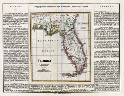
Map, Geographical-Statistical and Historical Map of Florida, 1828
Files
Download Full Text (34.4 MB)
Preview
Publisher
Verlag des Geographischen Instituts
Creation Date
1828
Abstract
A map of Florida in German that shows railroads, counties, cities and towns, and inland waters. The text around the map gives geographical, statistical, and historical information about Florida.
Alt Text
A map of Florida in German that shows railroads, counties, cities and towns, and inland waters. The text around the map gives geographical, statistical, and historical information about Florida.
Scale
3300000, Scale [ca. 1:3,300,000].
Extent
1 map
Language
German
Media Type
Map
Identifier
U15-9022
Recommended Citation
Geographisches Institut (Weimar, Thuringia, Germany), "Map, Geographisch-statistische und historische Karte von Florida, 1828" (1828). Florida Maps Collection. Image 133.
https://digitalcommons.usf.edu/fl_maps_collection/133
Rights Statement

