

Florida Maps Collection
Files
Download Full Text (46.1 MB)
Preview
Publisher
United States. Government Printing Office
Creation Date
1884
Abstract
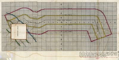
A plot map for land owned by the Florida Railroad Company. Note at the bottom of the plot map reads "See letter of March 16th, 1881, to R & R at Gainesville Florida, ordering the withdrawal of the odd numbered sections from disposal, and to hold subject to pre-emption settlement the even sections at $2.50 per acre, in the 'granted limits' and to permit (under the Act of March 3d, 1879,) homesteads upon even sections for 160 acres in said six mile limits." Written underneath in different-colored ink: "Receipt ackd by R & R March 26 1881 as having reached their office at 3 P.M. same day."
Alt Text
Map showing the Florida Railroad line between Township 8 South Range 22 East and 29 Township 29 South range 18 East. No features are shown on the map other than the Arredondo grant.
Keywords
Real property, Railroads
Scale
Scale not given
Extent
1 map
Physical Collection
Rare Map Collection
Language
English
Media Type
Map
Identifier
U15-0125
Recommended Citation
Florida Railroad Company, "Map, Florida Railroad Company Land Sections Available for Homesteading, 1884" (1884). Florida Maps Collection. Image 128.
https://digitalcommons.usf.edu/fl_maps_collection/128
Keywords
Real property, Railroads
Rights Statement

