

Florida Maps Collection
Files
Download
Download Full Text (42.9 MB)
Preview
Publisher
George F. Cram Company
Creation Date
1888
Abstract
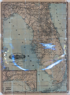
The George F. Cram Company produced this map of Florida for his Standard American Atlas of the World in 1887.
Alt Text
Map of Florida showing counties, cities, and railroads. An inset map is shown for the Florida panhandle.
Keywords
Railroads
Scale
1267200, Scale [1:1,267,200]. 20 miles to 1 in.
Extent
1 map
Physical Collection
Rare Map Collection
Language
English
Media Type
Map
Identifier
U15-0120
Recommended Citation
George F. Cram Company, "Map, Railroad and County Map of Florida, 1888" (1888). Florida Maps Collection. Image 127.
https://digitalcommons.usf.edu/fl_maps_collection/127
Keywords
Railroads
Rights Statement

