

Florida Maps Collection
Files
Download
Download Full Text (53.9 MB)
Preview
Publisher
Laurie & Whittle
Creation Date
1794
Time Period
1794
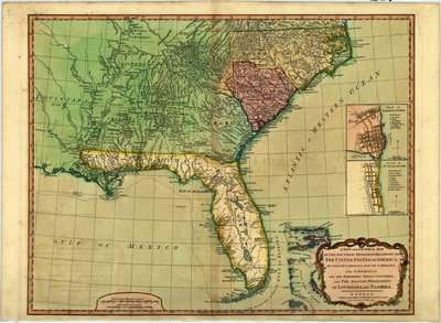
Abstract
with the bordering Indian countries, and the Spanish possessions of Louisiana and Florida
Keywords
Southern States, Southern States, Indians of North America
Subject: geographic
Southern States, Southern States
Holding Location
University of South Florida Library
Language
English
Format
Map
Identifier
U15-0005
Recommended Citation
Robert Laurie and James Whittle, "new and general map of the Southern dominions belonging to the United States of America, viz North Carolina, South Carolina, and Georgia" (1794). Florida Maps Collection. Image 121.
https://digitalcommons.usf.edu/fl_maps_collection/121
Keywords
Southern States, Southern States, Indians of North America
Rights Statement

