

Florida Maps Collection
Files
Download
Download Full Text (81.2 MB)
Preview
Publisher
G.W. & C.B. Colton & Company
Creation Date
1882
Abstract
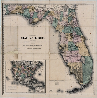
A map of Florida that shows railroads, counties, cities and towns and inland waters. There is an inset map of "North America south of the 55th Parallel showing the relative position of Florida."
Alt Text
Map of Florida with Counties shown in varying colors. An inset map exists in the bottom left showing the entire United States.
Keywords
Railroads
Scale
1140000, Scale 1:1,140,000. 18 miles to 1 in.
Extent
1 map
Physical Collection
Touchton Map Collection
Holding Location
Tampa Bay History Center
Language
English
Media Type
Map
Identifier
U15-9019
Recommended Citation
G.W. & C.B. Colton & Company, "Map, State of Florida, 1882" (1882). Florida Maps Collection. Image 115.
https://digitalcommons.usf.edu/fl_maps_collection/115
Keywords
Railroads
Rights Statement

