

Florida Maps Collection
Files
Download
Download Full Text (1.1 MB)
Preview
Publisher
W.D. Ticknor
Creation Date
1835
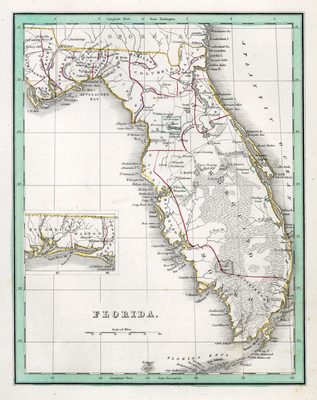
Abstract
A map of Florida, with an inset map showing the western Panhandle of the state. It shows counties, cities and towns, grants (Arredondos and Mirandas grants) and inland waters. It shows latitude from Greenwich and Washington.
Alt Text
A map of Florida with counties shown. Waterbodies and coastal islands are labeled on the map. An inset map is shown the Florida panhandle.
Scale
Scale not determined.
Extent
1 map
Language
English
Media Type
Map
Identifier
U15-9047
Recommended Citation
Boynton, George W., "Map, Florida, 1835" (1835). Florida Maps Collection. Image 104.
https://digitalcommons.usf.edu/fl_maps_collection/104
Rights Statement

