Environmental Lands Acquisition and Protection Program Collection
Files
Download Full Text (116 KB)
Preview
Creation Date
1980
Time Period
circa 1980s-2000s
Abstract
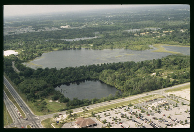
This aerial view captures Starvation Lake within Lake Park, surrounded by dense trees and greenery. Nearby roadways, parking lots, and commercial areas are also visible.
Alt Text
Aerial view of a large lake surrounded by dense forest and adjacent to a road with a parking lot. In the background, there are more lakes and a distant urban area.
Keywords
Environmental protection, Wildlife management, Wildland-urban interface, Aerial photography
Extent
1 color photograph
Subject: geographic
Hillsborough County (Fla.); Tampa (Fla.); Lake Park (Fla.)
Physical Collection
Environmental Lands Acquisition and Protection Program Collection
Digital Date
2021
Media Type
Color photographs
Identifier
E22-00463
Recommended Citation
Hillsborough County ELAPP, "Aerial View of Starvation Lake, Tampa, Florida" (1980). Environmental Lands Acquisition and Protection Program Collection. Image 211.
https://digitalcommons.usf.edu/elapp/211
Rights Statement