

Hampton Dunn Collection of Florida Postcards
Files
Download
Download Full Text (587 KB)
Preview
Publisher
I. Stern
Creation Date
1900
Time Period
circa 1900s
Abstract
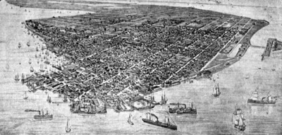
An early aerial view of Key West surrounded by ships.
Alt Text
An old map depicting a densely populated city with numerous buildings and streets, surrounded by water with several ships docked along the shoreline. The layout shows a grid-like pattern of streets and clusters of structures throughout the city.
Keywords
Aerial photography
Extent
1 postcard
Subject: geographic
Monroe County (Fla.); Key West (Fla.); Florida Keys (Fla.)
Physical Collection
Box
13
Folder
Monroe
Language
English
Media Type
Postcards
Identifier
D32-0993
Recommended Citation
Dunn, Hampton, "Bird's Eye View of Key West, A" (1900). Hampton Dunn Collection of Florida Postcards. Image 328.
https://digitalcommons.usf.edu/dunn_postcards/328
Keywords
Aerial photography
Image Location
Latitude
24.5555034669138
Longitude
-81.7812541540691
Rights Statement

