
Hampton Dunn Collection of Florida Postcards
Files
Download
Download Full Text (975 KB)
Preview
Creation Date
1900
Time Period
circa 1900s
Abstract
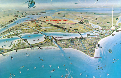
An aerial map of John F. Kennedy Space Center, Cape Kennedy, and neighboring cities.
Alt Text
A detailed map of the John F. Kennedy Space Center with labeled facilities and surrounding areas. The Atlantic Ocean is visible to the right, with various spacecraft and rockets depicted in flight or on display.
Keywords
Aerial photography, John F. Kennedy Space Center
Extent
1 postcard
Subject: geographic
Brevard County (Fla.); Titusville (Fla.)
Physical Collection
Box
1
Folder
Brevard
Language
English
Media Type
Postcards
Identifier
D32-0082
Recommended Citation
Dunn, Hampton, "Artist Conception of NASA's John F. Kennedy Space Center, Cape Kennedy, and Neighboring Cities" (1900). Hampton Dunn Collection of Florida Postcards. Image 12.
https://digitalcommons.usf.edu/dunn_postcards/12
Keywords
Aerial photography, John F. Kennedy Space Center
Image Location
Latitude
28.64262
Longitude
-80.70034
Rights Statement

