
Richard A. "Skip" Davis, Jr. Collection of Coastal and Geologic Illustrations
Files
Download
Download Full Text (3.4 MB)
Preview
Creation Date
January 1977
Time Period
circa 1977-1999
Alt Text
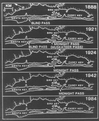
A series of maps showing the changes in landmass and waterways around Siesta Key, Bird Key, and Casey Key from 1888 to 1984. Each map highlights different passes and key locations over time.
Keywords
Index maps
Extent
1 black-and-white slide
Subject: geographic
Sarasota County (Fla.); Siesta Key (Fla.); Midnight Pass (Fla.); Casey Key (Fla.); Bird Key (Fla.)
Physical Collection
Language
English
Media Type
Black-and-white photographs
Identifier
D34-00609
Recommended Citation
Davis, Richard A., "Slide, Midnight Pass Changes" (1977). Richard A. "Skip" Davis, Jr. Collection of Coastal and Geologic Illustrations. Image 402.
https://digitalcommons.usf.edu/davis_coastal/402
Keywords
Index maps
Rights Statement

