
Richard A. "Skip" Davis, Jr. Collection of Coastal and Geologic Illustrations
Files
Download
Download Full Text (5.4 MB)
Preview
Creation Date
August 1997
Alt Text
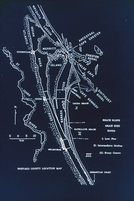
A detailed map of Brevard County showing various beaches, islands, and inland areas with labeled zones indicating beach slope and grain size. The map includes a scale and directional compass for reference.
Keywords
Intertidal zonation, Index maps
Extent
1 black-and-white slide
Subject: geographic
Brevard County (Fla.)
Physical Collection
Language
English
Media Type
Black-and-white photographs
Identifier
D34-00443
Recommended Citation
Davis, Richard A., "Slide, Index Map of Brevard County Coastal Area" (1997). Richard A. "Skip" Davis, Jr. Collection of Coastal and Geologic Illustrations. Image 347.
https://digitalcommons.usf.edu/davis_coastal/347
Keywords
Intertidal zonation, Index maps
Rights Statement

