

Catesby Collection
Files
Download Full Text (6.0 MB)
Preview
Publisher
Printed for C. Marsh [etc.]
Creation Date
1754
Abstract
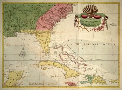
Map showing North and South Carolina, Florida, and the Bahamas including bordering colonies, Indigenous nations and places, the Gulf of Mexico, the Atlantic Ocean, and adjacent areas. From Volume 1 of Mark Catesby's Natural History of Carolina, Florida, and the Bahama Islands.
Alt Text
A historical map depicting the southeastern region of North America, including Florida and parts of surrounding areas. The map features color-coded regions and an ornate decorative element at the top center.
Keywords
Natural history, Pre-Linnean works, Southern states, Mark Catesby (1683-1749)
Extent
1 plate
Subject: geographic
North Carolina, South Carolina, Bahamas, Gulf of Mexico, Atlantic Ocean
Physical Collection
Vault
Call Number
Volume
1
Language
English
Media Type
Plates (Illustrations)
Identifier
C32-00006
Recommended Citation
Catesby, Mark and George, Edwin, "A Map of Carolina, Florida and the Bahama Islands with the Adjacent Parts" (1754). Catesby Collection. Image 6.
https://digitalcommons.usf.edu/catesby/6
Keywords
Natural history, Pre-Linnean works, Southern states, Mark Catesby (1683-1749)
Rights Statement

