Audubon Coastal Islands Sanctuaries - Images
Files
Download Full Text (22.7 MB)
Preview
Creation Date
1-1-1990
Abstract
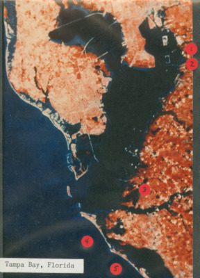
A photo of an aerial satellite photo of the Tampa Bay area. A darker red color signifies dense forested areas in the region. A separate photo of Whiskey Key Stump is seen in the same folder. This picture was provided by Richard Paul in partnership with the National Audubon Society's Florida Coastal Island Sanctuaries.
Keywords
Aerial views, Aerial photography, Islands, Nature conservation, Florida Audubon Society, Vegetation, Maps
Subject: geographic
Tampa Bay (Fla.)
Physical Collection
National Audubon Society Florida Coastal Islands Sanctuaries Collection
Box
53
Folder
01
Digital Date
2026
Identifier
audubon_coastal_islands_images_1057
Recommended Citation
Paul, Richard T., "Vegetation Map of Tampa Bay" (1990). Audubon Coastal Islands Sanctuaries - Images. Image 58.
https://digitalcommons.usf.edu/audubon_coastal_islands_images/58
Image Location
Latitude
27.6721088217026
Longitude
-82.6004473003783
Rights Statement