
Andean Archaeological Data Project - Images
Files
Download Full Text (2.6 MB)
Preview
Creation Date
2014
Alt Text
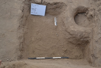
An archaeological excavation site with exposed soil layers and a small sign placed within the dug-out area. The site features distinct sections and markings, with a measuring stick visible for scale and another measurement tool beside a sign. There is a small circular structure visible in the dug trench.
Keywords
Archaeology
Extent
1 color photograph
Subject: geographic
South America; Perú; Ica (Perú : Region); Huaca Soto (Perú); Chincha Alta (Perú)
Media Type
Color photographs
Format
Digital Only
Identifier
H66-00097-00010
Creative Commons

This work is licensed under a Creative Commons Attribution-Noncommercial-No Derivative Works 3.0 License.
Recommended Citation
Stanish, Charles, "Sandy Level with Intact Olla Hole" (2014). Andean Archaeological Data Project - Images. Image 525.
https://digitalcommons.usf.edu/andean_adp/525
Keywords
Archaeology
