
Binder 19: Photographs and Images
Files
Download Full Text (6.0 MB)
Preview
Creation Date
8-24-1992
Abstract
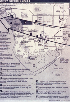
Map of South Florida showing the path of Hurricane Andrew from the Miami Herald. Elliott Key in Biscayne National Park (BNP) is #12 on the map.
Alt Text
A map of the Hurricane Andrew's path through Everglades National Park showing various locations and points of interest with labels and a legend. The map highlights areas affected by the environmental event, marked with numbers and descriptions.
Keywords
Hurricanes, Hurricane Andrew (1992), Extreme weather, Natural disasters
Extent
1 map
Physical Collection
Box
7
Folder
Binder 19
Language
English
Digital Date
2024
Media Type
Maps
Identifier
O19-02874
Recommended Citation
Porter, James W., "Map, Hurricane Andrew Near Everglades National Park, 1992" (1992). Binder 19: Photographs and Images. Image 55.
https://digitalcommons.usf.edu/ogden19_images/55
Keywords
Hurricanes, Hurricane Andrew (1992), Extreme weather, Natural disasters
