
![Sustainable Design, Planning and Community Development [Monteverde Institute]](../../assets/md5images/b75c0d8fdc2d2e56ad6f666ecb526758.jpg)
Sustainable Design, Planning and Community Development [Monteverde Institute]
Files
Download Full Text (1.5 MB)
Publication Date
January 2004
Abstract
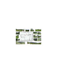
Hand-rendered map of San Luis, with legend, surrounded by images of structures in the town. Each image is numbered with its corresponding number located on the map.
Resumen
Una representación a mano de un mapa de San Luis, con leyenda, rodeado por imágenes de las estructuras en el pueblo. Cada imágen esta numerado con su número correspondiente localizado en el mapa.
Keywords
Strategic planning, Community development, Sustainable Futures 2004
Palabras claves
Planeamiento estratégico, Desarrollo comunal, Futuros Sostenibles 2004
Extent
1 rendering with 15 photographs
Geographic Location
San Luis (Puntarenas, Costa Rica)
Holding Location
Monteverde Institute
Media Type
Renderings (Drawings); Photographs
Format
Digital Only
Identifier
M37-00091
Creative Commons

This work is licensed under a Creative Commons Attribution-Noncommercial-No Derivative Works 3.0 License.
Type
Book
Recommended Citation
Monteverde Institute, "Grupo Tres: 1 de 2, 2004" (2004). Sustainable Design, Planning and Community Development [Monteverde Institute]. 81.
https://digitalcommons.usf.edu/sustainable_futures/81
